The Nazca Lines — drawings that only come together from afar
No one excavated anything there. It was enough to move the dark stones out of the way and pile them along the edges for a pale furrow a few centimeters deep to appear. Repeated over kilometers, in a desert where it almost never rains, that lasted two thousand years — and became the most-viewed-from-above riddle in all of archaeology.
- Where
- Pampa de Nazca, Ica region, Peru
- Period
- ≈ 500 BC – AD 500
- Made by
- the Paracas and Nasca cultures
- Area of the lines
- ≈ 450 km²
- Known figures
- 893 (2025)
- World Heritage
- 1994
Between the Ingenio and Nazca rivers, on the southern coast of Peru, there is a flat, dry plateau some four hundred kilometers from Lima. The ground is covered by a gravel of reddish stones, darkened by an iron oxide patina that takes centuries to form. Beneath that layer, the soil is yellowish and pale. That is all the raw material the lines needed.
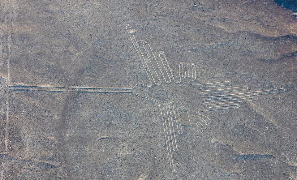
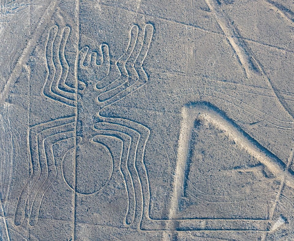
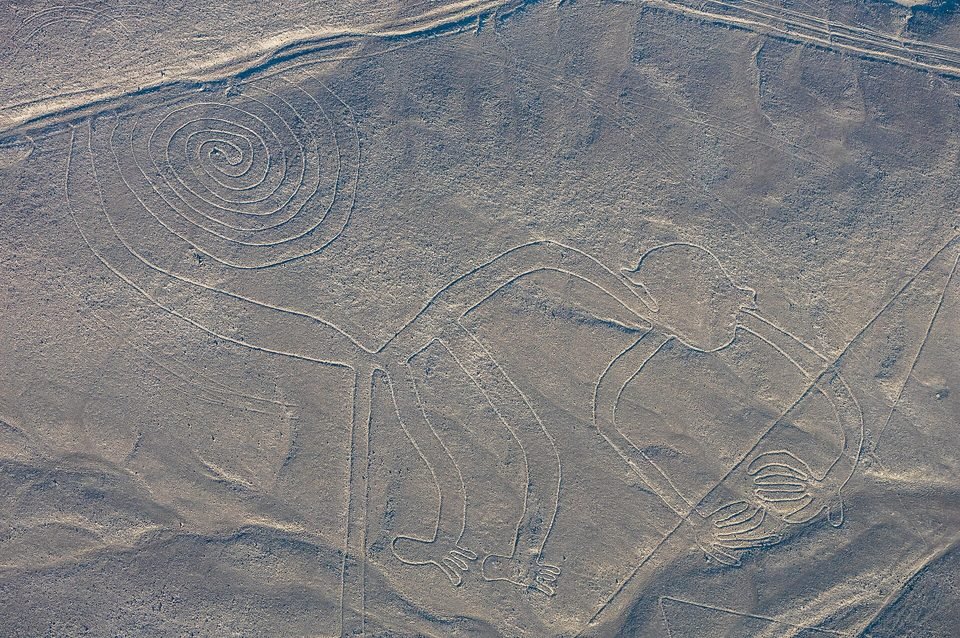
Whoever crosses the pampa on foot sees little: paler strips vanishing toward the horizon, small mounds of stone, tracks that cross one another. Whoever climbs a nearby hill begins to notice that the strips are too straight to be ordinary paths. And whoever flies over, a few hundred meters up, sees a hummingbird, a monkey, a spider, a whale, a condor — and a mesh of straight lines, triangles and trapezoids running across everything.
That difference in point of view is the center of the story. It fed a century of theories, some serious and others fanciful, and only in 2024 did it get a sharper answer: not all the drawings were made for the same gaze.
01What is on the ground
Researchers divide what exists on the pampa into three families. The straight lines, which are the majority: strips ranging from a few dozen meters to several kilometers, often radiating from the same small hillock like the spokes of a wheel. The geometric figures — trapezoids, triangles and spirals, some hundreds of meters long with the area of a soccer field. And the figurative drawings, the famous animals and plants, which are a minority and occupy a small part of the total area.
The technique is always the same, and it is remarkably economical. The dark surface stones are pushed aside, piling up in small ridges on both sides; what is left exposed is the pale soil beneath. The furrows are generally ten to fifteen centimeters deep, and more than half of the lines are just over thirty centimeters wide. Nothing was dug in the proper sense, nothing was built. The drawing is a difference in color.
What made that difference last is the place. The region is among the driest on the planet, with rare rain and a wind that, close to the ground, barely moves the gravel. The dark stones absorb heat and create a layer of warmer air over the surface, which helps protect the drawing. It is a fragile preservation: a foot or a tire makes in a minute a mark that nature does not erase in centuries.
02Who scratched them, and when
The Nasca culture occupied the valleys of Peru's southern coast roughly between the first century BC and the seventh century AD. It was a society of farmers in very dry valleys, famous for its polychrome pottery and for underground water-catchment galleries, the puquios, which some researchers attribute to it and others to later periods. The great ceremonial center was Cahuachi, a complex of adobe mounds on the bank of the Nazca River, a few kilometers from the pampa.
Before it came the Paracas culture, which was already scratching figures — mostly on hillsides, so as to be seen from below. To this phase are attributed the "cat" found in 2020 on a slope, while an access trail to a viewpoint was being cut, and many of the human figures of Palpa, to the north.
Dating a furrow in the ground is hard, because there is no organic material inside it. The chronology comes from indirect evidence: fragments of pottery broken on the lines and in the stone mounds at their ends, whose style has a known date; the resemblance between the animals on the ground and those that appear on Nasca vessels and textiles; and the order in which one line cuts another. The result is the range UNESCO adopts, from about 500 before Christ to 500 after Christ, with the hillside figures older and the great straight lines and trapezoids later.
03Who saw them first
The lines were never hidden. The Spanish chronicler Pedro Cieza de León mentioned in 1553 signs in the desert that he took for trail markers. The first to treat them as an object of study was the Peruvian archaeologist Toribio Mejía Xesspe, a collaborator of Julio C. Tello, who walked them in 1927, looking from the hills. He interpreted them as ceremonial paths and presented the idea at a congress in Lima in 1939 — before any famous aerial photograph.
The next push came from the American historian Paul Kosok, who studied ancient irrigation on the Peruvian coast. In 1940 and 1941 he crossed the pampa and, according to the account that became famous, saw the sun set along the extension of one of the lines on the day of the southern hemisphere's winter solstice, in June 1941. It was Kosok who recognized the drawing of a bird among the lines and who launched the idea that the pampa was "the largest astronomy book in the world."
The work was inherited by a German translator and teacher who had accompanied him: Maria Reiche, born in Dresden in 1903, in Peru since 1932. From 1946 she devoted herself to the pampa almost alone — measuring with a tape, sweeping furrows to make them visible, mapping figures no one had drawn. She published The Mystery on the Desert in 1949 and spent the rest of her life defending the astronomical hypothesis.
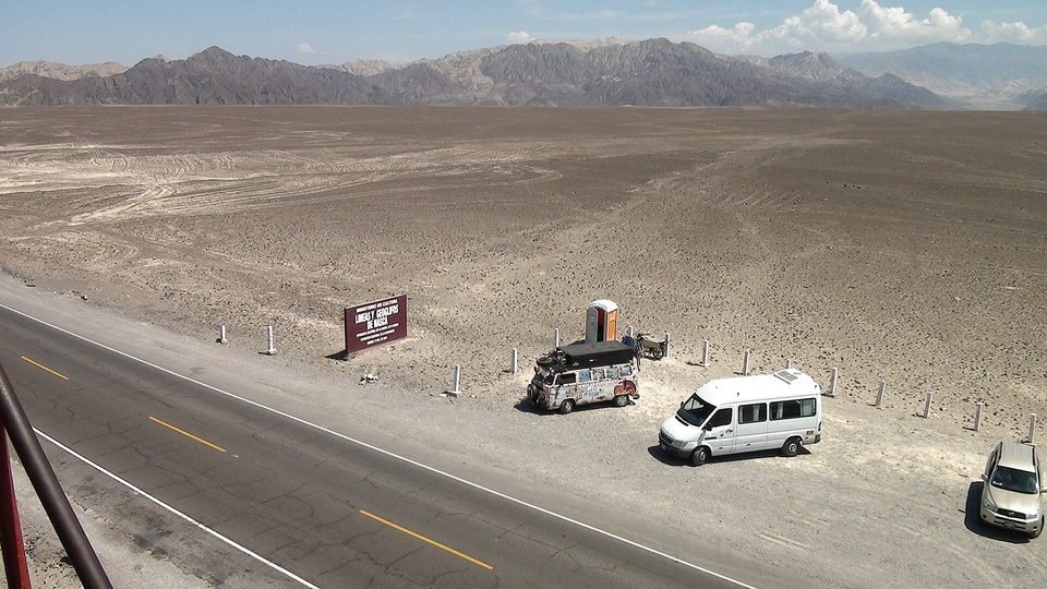
Her theory aged badly; her preservation work did not. Reiche paid guards out of her own pocket, got flights from the Peruvian Air Force to photograph the pampa, financed the observation tower beside the Pan-American Highway and insisted for decades on restricting car access. She died in Lima on June 8, 1998, four years after the Lines and Geoglyphs of Nasca and Palpa were added to the World Heritage List — an inscription for which her campaign counted for a great deal.
04How they were made
The question "how did they draw something they could not see?" has a simple answer, and it has been tested. In 1982, the American investigator Joe Nickell reproduced the Nazca condor, about 134 meters long, in a field in Kentucky. He used what the Nasca had: a small drawing, wooden stakes, knotted cords for measuring, and a makeshift square made of two slats. The team was made up of his relatives, with no technical training. The work took about a day and a half, much of it lost to rain, and the aerial photograph showed a figure very close to the original.
The most likely method is to enlarge a small model by coordinates: fix a point, measure the distance and direction to the next one with a cord, and so on. The curves can be traced with a cord tied to a stake, like a compass. Remains of wooden stakes have been found at the ends of some lines. For the long straight lines, it is enough to line up three stakes by eye and keep going — the kilometers-long precision without deviation, which impresses so many, is the easiest thing to achieve with this technique.
As for the labor, the estimates point to something within reach of small groups. Clearing the gravel from a large figure is a matter of days for a few dozen people. Over a thousand years, that easily accounts for everything on the pampa, without any technology that did not exist on the Peruvian coast at the time.
05What they were for: the readings, from the most solid to the most improbable
This is the part where the debate is still alive. The hypotheses below do not all exclude one another — several may have been true at different times, or for different types of line. The weight of evidence indicates how much each one rests on what has been measured and excavated.
Paths for walking, in ritual
Mejía Xesspe's idea has come back strongly. Many figures are drawn with a single line, which can be walked from one end to the other without crossing itself — the hummingbird and the monkey are among them. The straight lines and trapezoids show, at several points, trampled ground and pottery deliberately broken, as in offerings. In 2012, Clive Ruggles and Nicholas Saunders described in the journal Antiquity a 4.4-kilometer "labyrinth," a single path full of turns, which only makes sense to someone walking it — and which Ruggles identified by walking.
The most accepted reading today is that the pampa was a space for procession and ceremony, used by groups who walked along the lines, and not an image to be contemplated from above.
Water, mountains and fertility
In a place where survival depended on rivers that come down from the Andes a few months a year, it would be strange if water were not at the center of religion. The anthropologist Johan Reinhard brought together archaeological and ethnographic data in 1985 to propose that the lines were part of the worship of mountains and water sources. Aveni and Urton observed that the ray centers sit on small rises near where water reaches the valleys, and that many straight lines point toward watercourses.
A more specific variant — that the lines marked underground aquifers and geological faults, proposed by David Johnson in the 1990s — drew attention but has not been confirmed by independent studies.
Two types of drawing, for two audiences
It is the proposal of the Yamagata University team, published in 2024 on the basis of the figures found with artificial intelligence (section 06). The large line figures show mostly wild animals and lie along the network of straight lines and trapezoids: they would have been the stage for collective rituals. The small relief figures, about ten meters across on average, show human motifs — people, domesticated llamas, severed heads — and lie beside narrow trails, at a distance at which a walker can see them from the ground. They would have been meant to be seen by individuals or small groups, in passing.
The hypothesis fits the observed distribution. It is still one team's interpretation, and it depends on the sample of trails being representative.
An astronomical calendar
It is the thesis of Kosok and Reiche, and it was the most influential for decades. In 1968, the astronomer Gerald Hawkins — known for having argued for astronomical uses at Stonehenge — tested 186 lines by computer against the positions of the Sun, the Moon and bright stars on the horizon of the period. Thirty-nine matched important solar or lunar directions, but about half of that could be explained by chance, and identical figures in different places gave different results. His conclusion was that astronomy did not explain most of the lines.
That does not rule out that some straight lines marked a solstice or the rising of a star, as Kosok saw in 1941. It rules out the pampa as a systematic observatory.
Landing strips for visitors from space
Popularized by Erich von Däniken in the book Chariots of the Gods?, from 1968, the idea is that the trapezoids resemble airport runways and that the figures were signals for those arriving from the sky. The ground itself answers: the exposed soil is soft, and any heavy vehicle sinks and leaves a mark — as the 2018 truck showed (section 07). A "runway" thirty centimeters wide, or drawn as a monkey, is no good for landing anything.
The underlying argument — "no one would make something they cannot see" — has been answered by Nickell's experiment and by the hillside figures that can be seen from below. And it shifts authorship away from the people who actually made the lines, whose vessels and textiles bear the same animals that are on the ground.
06Discovered yesterday: what artificial intelligence found
For eighty years, the Nazca figures were found one at a time — on a flyover, in a photograph, on a walk across the pampa. Yamagata University, in Japan, has run an institute devoted to the region since 2012, under the direction of the archaeologist Masato Sakai, and in the late 2010s began working with IBM Research. In 2019 the group announced 143 new figures, one of them first detected by a machine-learning model. In 2022, another 168.
The leap came in 2024. On September 23, the team published in the journal Proceedings of the National Academy of Sciences the result of a sweep of the entire pampa with a detection model trained on aerial photographs at ten-centimeter resolution. After a first screening, 1,309 high-potential candidates remained; the archaeologists went into the field, checked them by drone and, in six months of work, confirmed 303 new figurative geoglyphs. Until then 430 were known. The number nearly doubled in a semester.
The finds are almost all of the small relief type — hard to see from a plane because they are only a few meters across, eroded and in low contrast with the ground. The AI did not "discover" them on its own: for each real figure, the researchers had to examine dozens of the model's suggestions. The gain was in speed, estimated by the team at about sixteen times.
On July 28, 2025, at the Peru pavilion at Expo 2025 in Osaka, Sakai announced another 248 geoglyphs, found in the 2023 and 2024 campaigns with the same method: 160 figurative — among them human figures, decapitation scenes and llamas — and 88 geometric. With that, the total of known figurative geoglyphs on the pampa reached 893. The team estimates that there are more than a thousand relief figures along more than a hundred trails — which still leaves dozens, perhaps hundreds, to be found.
07The threats
The same ground that kept the lines for two thousand years leaves them defenseless against any wheel. The Pan-American Highway, opened in the 1930s, crosses the pampa in a straight line and runs right over the lizard geoglyph, which was cut in half. The viewing towers that exist today beside the road came about, in part, from the attempt to keep visitors off the ground.
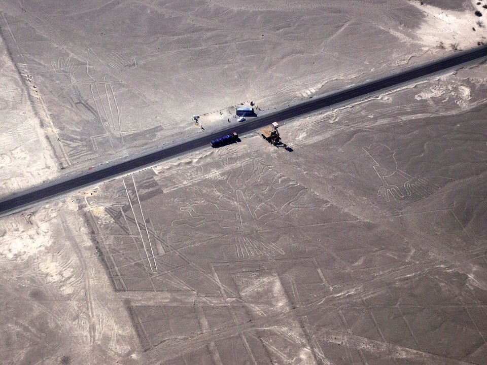
December 2014. During the UN climate conference in Lima, Greenpeace activists entered the restricted area next to the hummingbird and laid out yellow cloth letters with a message about renewable energy. The group's footprints were left marked on the ground, and the Peruvian government took legal action. The organization apologized.
January 2018. A truck driver ignored the signs and drove across the pampa, leaving deep ruts over an area of about 50 by 100 meters and damaging stretches of three straight lines. He was detained and released; the court saw no intent.
May and June 2025. The Ministry of Culture reduced the area of the archaeological reserve from 5,600 to about 3,200 km² — a cut of 42%, which small-scale miners had been asking for. In the face of the reaction from archaeologists and the press, the ministry itself annulled the measure days later and restored the 2004 perimeter, announcing an executive unit to manage the reserve.
2026. The pressure did not stop. In July, the Peruvian press reported complaints of more than 130 illegal ore-processing plants in the region, and the ministry announced the cleanup of six hectares of garbage in the Socos sector, inside the reserve, paid for with revenue from the tourist ticket. At the end of September, an inspection by the Ministry of Culture with the Public Prosecutor's Office and the police at the Bogotalla–Tulín Archaeological Landscape, in the district of El Ingenio, found heavy machinery, a camp, newly opened roads and the mouth of a mine tunnel — about seventy meters from the nearest geoglyph. The area had been declared cultural heritage of the nation in October 2025.
08Chronology
- ≈ 500 – 200 BCParacas phase: figures mostly on hillsides, visible from below, at Palpa and on the edge of the pampa.
- ≈ 100 BC – AD 500Nasca phase: the large line figures, the straight lines, the trapezoids. Cahuachi is the ceremonial center.
- 1553Pedro Cieza de León mentions signs in the desert, which he takes for trail markers.
- 1927Toribio Mejía Xesspe walks the lines and interprets them as ceremonial paths. He presents the study in 1939.
- 1930sThe Pan-American Highway is opened across the pampa and cuts through the lizard geoglyph.
- June 1941Paul Kosok observes the solstice sunset aligned with a straight line and recognizes the figure of a bird.
- 1946 – 1949Maria Reiche begins the systematic mapping of the figures and publishes The Mystery on the Desert.
- 1968Gerald Hawkins tests 186 lines by computer and concludes that astronomy does not explain most of them. The same year, von Däniken launches the "runways" thesis.
- 1982Joe Nickell reproduces the condor, at full size, with stakes and cords, in a field in Kentucky.
- 1980sAveni and Urton map about 800 straight lines and 62 ray centers. Reinhard publishes the water-and-mountains hypothesis (1985).
- 1994The Lines and Geoglyphs of Nasca and Palpa are added to the UNESCO World Heritage List.
- June 8, 1998Maria Reiche dies in Lima, aged 95.
- 2012Ruggles and Saunders publish the 4.4 km "labyrinth" made to be walked. Yamagata University opens its institute in Nasca.
- December 2014Greenpeace activists leave footprints next to the hummingbird.
- January 2018A truck drives across the pampa and damages three straight lines.
- 2019 and 2022Yamagata and IBM announce 143 and then 168 new figures.
- October 2020Announcement of the Paracas-phase "cat," found on a slope during work on a viewpoint.
- September 23, 2024Paper in PNAS: 303 new figurative geoglyphs found with artificial intelligence in six months.
- May – June 2025The government cuts 42% of the archaeological reserve and backs down days later.
- July 28, 2025Another 248 geoglyphs announced at the Osaka Expo; known figurative geoglyphs reach 893.
- August 1, 2026The crash of a tourist plane that was to fly over the lines leaves thirteen dead.
- late September 2026An inspection finds illegal mining about 70 meters from a geoglyph at Bogotalla–Tulín, inside the reserve.
09What remains open
What each type of line was for. Ritual path, water, procession, marking of groups: the serious hypotheses do not exclude one another, and the pampa was used for a millennium. The answer is probably different for a Paracas hillside figure, for a Nasca hummingbird and for a late trapezoid.
How many figures are still there. The Yamagata team's estimate is more than a thousand relief figures; more than eight hundred have already been located. Each one found beside a trail strengthens or weakens the reading of the trails as routes of passage.
Finer dates. Almost the entire chronology comes from pottery style and from the overlap between lines. Methods that date the moment a stone was turned over, or the soil exposed, could separate phases that are blurred together today.
Whether protection matches the scale of the problem. The reserve is larger than many cities, surveillance is thin, and the threats of 2025 and 2026 came from inside the perimeter. The artificial intelligence that finds new figures is also being used to map the risk of flooding and encroachment; the question is whether the pace of protection keeps up with that of discovery.
10Frequently asked questions
What are the Nazca Lines?
They are drawings scraped into the desert floor: straight lines, geometric figures such as trapezoids and spirals, and figures of animals, plants and people. The dark surface stones were pushed aside, and the drawing is the difference in color of the pale soil left exposed.
Where are the Nazca Lines in Peru?
On the Pampa de Nazca, a dry plateau between the Ingenio and Nazca rivers, in the Ica region, on Peru's southern coast, some four hundred kilometers from Lima. The lines cover about 450 km², within an archaeological reserve of 5,600 km².
Who made the Nazca Lines?
The Paracas and Nasca cultures, between about 500 before Christ and 500 after Christ. The same animals that are on the ground appear on Nasca vessels and textiles. See Who scratched them, and when.
How were the Nazca Lines made?
The most likely method is to enlarge a small drawing with wooden stakes and cords, measuring the distance and direction from one point to the next. In 1982, Joe Nickell reproduced the condor this way, about 134 meters long, in about a day and a half. See How they were made.
What were the Nazca Lines for?
It is still debated. The most accepted reading today is that the pampa was a space for procession and ceremony, walked on foot; the connection with water and mountains also has support, and the astronomical-calendar thesis carries little weight. See the readings.
11Sources consulted
This dossier is original writing. The sources below were consulted to verify dates, measurements and attributions; none was reproduced.
- UNESCO World Heritage Centre — Lines and Geoglyphs of Nasca and Palpa (inscribed in 1994), property data and state of conservation reports.
- Consolidated encyclopedic entries on the Nazca Lines, the Nasca culture, Maria Reiche and Gerald Hawkins.
- Reiche, M. — The Mystery on the Desert. Lima, 1949.
- Hawkins, G. S. — computer study of the alignments of the Nazca lines, 1968–1969.
- Nickell, J. — full-size reproduction of the Nazca condor, 1982; account published in Skeptical Inquirer, 1983.
- Reinhard, J. — The Nazca Lines: A New Perspective on their Origin and Meaning. Lima, 1985.
- Aveni, A. F. (ed.) — The Lines of Nazca. American Philosophical Society, 1990; with Urton, G., on the ray centers.
- Ruggles, C.; Saunders, N. J. — Desert labyrinth: lines, landscape and meaning at Nazca, Peru. Antiquity, December 2012.
- Sakai, M. et al. — AI-accelerated Nazca survey nearly doubles the number of known figurative geoglyphs and sheds light on their purpose. PNAS, September 23, 2024; press releases from Yamagata University, IBM Research and the DLR.
- Yamagata University and PromPerú — announcement of 248 new geoglyphs at the Peru pavilion, Expo 2025 Osaka-Kansai, July 28, 2025.
- Press coverage of the Greenpeace action (December 2014) and of the truck on the pampa (January 2018).
- La República, Infobae and Actualidad Ambiental — reduction and restoration of the area of the Nasca archaeological reserve, May and June 2025.
- La República — report of illegal processing plants and works in the Socos sector, July 8, 2026.
- Infobae and Diario La Opinión (Ica) — inspection at the Bogotalla–Tulín Archaeological Landscape, reports of September 28 and 29, 2026.
- Al Jazeera and ABC News — crash of the tourist plane in the Ica region, August 1, 2026.