Nan Madol — the city on the reef
Ninety-two artificial islets, raised on living coral in the middle of the Pacific, with some seven hundred and fifty thousand tons of basalt — and columns brought from the other side of the island. The question is not who built it — that is known. It is how the stone traveled forty kilometers of coastline by sea.
- Where
- Temwen, Pohnpei, Micronesia
- Coordinates
- 6°50′31″N 158°19′56″E
- Islets
- 92 (counts go to 100+)
- Protected area
- 76.7 ha
- Megalithic from
- AD 1180
- World Heritage
- UNESCO, 2016
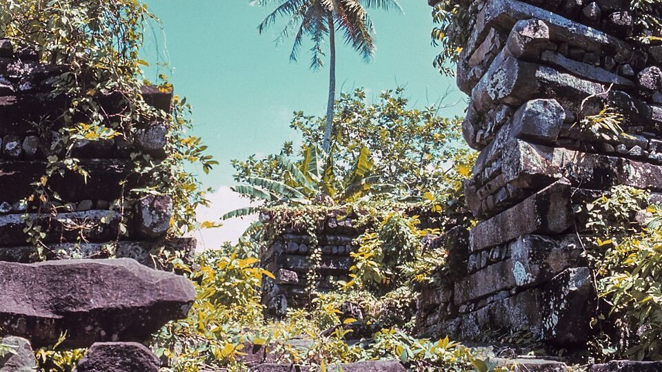
The tide rises and falls twice a day between the walls. When it is high, you can enter the canals by boat and pass between walls of black stone that rise out of the water without a single step, a single quay, a single stairway — they simply begin. When it ebbs, what lies beneath appears: coral, mud, advancing mangrove, and the base of the walls set directly on the reef. The silence is that of a forest, not of a ruin. Nan Madol is not a site in the middle of nowhere; it is a site in the middle of the water, a few meters from an inhabited coast.
The name means, roughly, the space between things, and it refers to the canals. They are neither moat nor defense: they are streets. The city was designed to be traveled by canoe.
It is the only city in the world built on a coral reef, and for almost a century it was treated as an inexplicable enigma. It is not. It is known who built it, for whom, why and — since 2016 — when, to within twenty years. What remains unanswered is one thing only, and it is mechanical.
01What it is, exactly
The core covers about 1.5 by 0.5 kilometers on the eastern edge of Pohnpei, next to Temwen Island. There are 92 artificial islets — platforms of stone and coral rubble — separated by canals that fill and empty with the tide. Different counts reach more than a hundred, depending on what is considered an independent islet. The area protected by UNESCO is 76.7 hectares, with a buffer zone of 664, and the larger archaeological district exceeds 18 km².
The complex has two functional halves. Madol Pah, to the southwest, was the administrative and residential sector of the elite. Madol Powe, to the northeast, with 58 islets, was the mortuary and priestly sector — and in it stands Nandauwas, the royal funerary enclosure, whose outer walls are between 5.5 and 7.5 meters high.
Individual islets had declared functions: food preparation, canoe building, ritual, burial. None of them produced food, and none had fresh water. Everything — every meal, every liter of drinking water — came up by canoe, every day, from the interior of the main island.
02The stone
Pohnpei is a volcanic island, and in some places the lava cooled into columnar basalt — those prismatic columns, five- or six-sided, that nature produces through thermal contraction. They are, in effect, ready-made beams. The construction of Nan Madol consists of stacking them horizontally, alternating direction with each course, in what architecture calls header-and-stretcher and any child calls a log-cabin wall. Between the walls, coral rubble. Mortar, none.
Volume is the point. The most cited estimate for the complex is about 750 thousand tons of basalt — a figure attributed to the Pohnpeian archaeologist Rufino Mauricio and never published with a methodology, which is worth keeping in mind before doing any math with it.
For the individual pieces, the gap between the measured number and the repeated number is glaring. The only published survey of weights — 69 pieces sampled on ten islets — found columns with an average of 0.8 ton, the heaviest at 9.5, and foundation boulders reaching about 25 tons. Widely circulated teaching material, academic material included, speaks of columns of 80 to 90 tons each; no measurement supports this, and the number should be treated as citation folklore.
Analysis by portable X-ray fluorescence — which reads the chemical composition of the rock without removing a sample — separated the two halves of the problem. The columns match sources on the opposite side of Pohnpei, among them the Sokehs outcrops: something around forty kilometers following the coast. The truly large stones, however — the foundation boulders, the heaviest on the site — came from Temwen Island, right next to Nan Madol. The authors caution that many of the island's sources have similar chemistry and that the geological sampling covers only a fraction of them: the attribution is probable, not settled.
03Who ruled there
Nan Madol was the capital of the Saudeleur dynasty, and the regime was explicitly absolutist: the land, what was on it and who lived on it belonged to the Saudeleur. Oral tradition attributes the founding to two sorcerer brothers, Olisihpa and Olosohpa, who are said to have come from abroad looking for a place to raise an altar for their worship.
The system was one of tribute. Subjects delivered breadfruit in the season of plenty, the rak; yam, taro and fermented breadfruit in the season of scarcity, the isol. Over the generations, the demands grew until the common people were reduced to working essentially to support the elite. The central cult was to the thunder god, Nahn Sapwe.
And here comes the number that reorganizes how the site is perceived. Pohnpei had an estimated population of 25 thousand people. The elite who actually lived in Nan Madol almost certainly numbered no more than a thousand — and could have been half that. It is not a city in the usual sense. It is a closed court, sustained by an entire island, living on top of the water in full view of everyone.
04The date that changed everything
In 2016, a team led by Mark McCoy published the result that put the site's chronology in order, and the method deserves an explanation because it is elegant.
Nan Madol is made of basalt and of coral. The coral used as fill and as offering takes up uranium from seawater while it is alive, and does not take up thorium. After it dies, the uranium begins to decay into thorium at a known rate. Measuring the ratio between the two gives the date of that coral's death — and therefore of the moment it was broken off and placed in the construction. This is uranium-thorium dating, and it is far more precise than radiocarbon in this time range.
The result fixed the start of megalithic construction within a twenty-year window, between AD 1180 and 1200, with the burial of the first chief taking place by 1200. That is more than a century earlier than the previously accepted date, around 1300.
The consequence is not chronological, it is political. If the monumental tomb of the first chief dates from 1180, then Nan Madol is the oldest evidence of a centralized chiefdom anywhere in the Pacific — a form of society that Pacific Islanders created on their own. It is not an island that received civilization. It is an island that invented one.
05The fall
The end has a name. Tradition holds that Isokelekel, a semi-divine figure, arrived with 333 men, women and children, with the secret intention of conquering Pohnpei. He cultivated an alliance with the discontented — who, after generations of tribute, were not in short supply — and confronted the Saudeleur. The versions differ on the trigger; they agree on the outcome.
The last ruler, Saudemwohl, is said to have retreated uphill to a stream, where he turned into a fish. It is the kind of detail that written sources do not confirm and that oral tradition preserves with precision — and it is worth recording for what it is: memory, not chronicle.
Isokelekel took the title of Nahnmwarki and exchanged absolute power for a decentralized structure of chiefdoms. Archaeological dating places the break around 1628; oral tradition prefers the sixteenth century. Nan Madol gradually lost its function and ended up abandoned. Tribute diminished, but survived as custom.
The Nahnmwarki system that Isokelekel founded still exists on Pohnpei, with titles recognized and held today. What separates Nan Madol from an abandoned ruin
This needs to be clear, because it is what rules out half of the exotic theories about the place: the lineage was not lost. The descendants of the society that built Nan Madol are on Pohnpei, with titles and traditional authority still in force. The site is theirs, it is sacred, and access to parts of it depends on permission.
06The readings, from the most sober to the most improbable
A Pohnpeian work, raised by a local chiefdom over centuries
It is the reading that practically everything supports. The rock has been chemically matched to quarries on the island itself. The chronology was fixed by uranium-thorium between 1180 and 1200. The political system that built it is documented, has a name, has a described tribute structure and has a living successor in the Nahnmwarki system.
There is not a single element of the site that requires an explanation from outside. The open question is one of logistics, and logistics is not a mystery of origin — it is an unsolved engineering problem.
The transport was by raft, riding the tide
The standard hypothesis: columns lashed beneath bamboo rafts, flotation assisted by the water itself, movement taking advantage of the tidal current around the island. It is the method Pacific peoples used to move heavy cargo in other contexts, and it explains the modest pace of about 1,850 tons per year.
What is missing is direct evidence — no raft, no lashing, no record. And a test is missing: as far as is known, no one has rebuilt a raft of this kind and tried to move a basalt column along the coast of Pohnpei. Until that experiment is done, the hypothesis remains reasonable and unverified.
The scale exceeds what 25 thousand people could have done
It is the intuition that feeds almost all speculation about the site, and it dissolves with a single division. Seven hundred and fifty thousand tons spread over four centuries come to about 1,850 tons per year, or something close to five tons per calendar day — half a dozen columns of the average size measured on the site.
For a society with compulsory tribute, seasonal labor in the season of plenty and four hundred years of political continuity, this is no inexplicable feat: it is a small building site running for a very long time. The impression of impossibility comes from looking at the total and forgetting to divide by the time span.
It is what remains of Mu, a continent sunk in the Pacific
The idea of a lost continent in the Pacific was invented in the nineteenth century and popularized by authors who never set foot in Micronesia. Nan Madol became its favorite showcase because it is made of stone, sits on the water and has a name that sounds foreign to the reader.
The answer is as direct as it gets: the basalt has been chemically traced to quarries on Pohnpei, the coral has been dated, the dynasty has a name and a documented succession, and the heirs of the political system that built the city hold titles on the island today. Attributing the work to an imaginary continent adds no mystery — it takes authorship away from people who are still there to claim it.
07Chronology
- first century ADFirst signs of human occupation in the Nan Madol area, with activity recorded around AD 80 to 200.
- eighth – ninth centuriesConstruction of the artificial platforms on the reef begins, still without megalithic architecture.
- 1180 – 1200Start of megalithic construction and burial of the first chief, fixed by uranium-thorium dating of coral. It is the oldest evidence of a centralized chiefdom in the Pacific.
- c. 1200 – 1600Height of the Saudeleur dynasty. Tribute intensifies and discontent grows, above all in the west of the island.
- c. 1628Isokelekel overthrows the last Saudeleur and founds the Nahnmwarki system. Oral tradition places the episode in the sixteenth century.
- 1874The Polish ethnographer John Stanislaw Kubary makes the first detailed description of the site for European readers.
- 1985Nan Madol is declared a National Historic Landmark by the United States, then administrators of the territory.
- 2012McCoy and Athens publish the chemical sourcing by X-ray fluorescence: columns consistent with sources on the opposite side of the island, foundation boulders coming from Temwen.
- 2016Mark McCoy's team publishes the uranium-thorium dating that fixes the start of megalithic construction between 1180 and 1200.
- 2016UNESCO inscribes the site on the World Heritage List under criteria (i), (iii), (iv) and (vi) — and places it, at the same session, on the List of World Heritage in Danger.
08What remains open
The transport. It is the central question and the only one that remains entirely without a material answer. No vessel, no lashing, no record. The raft hypothesis has never been tested in the field, and testing it is perfectly feasible — all it would take is one column, one raft and one tide.
Why it was abandoned. The fall of the Saudeleur explains the change of power, but it does not explain why the place emptied out. Isokelekel even took up the title there. Keeping the court cost the same daily labor of food and water it always had; perhaps the answer is simply that — that no one wanted to pay the bill anymore.
And whether anything will be left. This is the urgent point. UNESCO inscribed Nan Madol in 2016 and, at the same session, placed it on the List of World Heritage in Danger — which is rare and says it all. The reason is concrete: the silting of the canals feeds the uncontrolled advance of the mangrove, whose roots work their way between the columns and take the walls apart from the inside out. Add to that vegetation on top, storm surge and masonry collapse. The city that withstood eight hundred years is being taken apart by trees.
09Frequently asked questions
Where is Nan Madol located?
On the eastern edge of Pohnpei, in Micronesia, next to Temwen Island. The core covers about 1.5 by 0.5 kilometers, on the coral reef, a few meters from an inhabited coast.
What is Nan Madol?
A complex of 92 artificial islets of basalt and coral, separated by canals that fill with the tide. It was the capital of the Saudeleur dynasty: an administrative and residential sector for the elite and a mortuary and priestly sector. See what it is, exactly.
Who built Nan Madol?
The Pohnpeians themselves, under the Saudeleur chiefdom. The rock has been chemically matched to quarries on the island, and uranium-thorium dating of coral fixes the start of megalithic construction between AD 1180 and 1200. See the date that changed everything.
How was Nan Madol built?
With basalt columns stacked horizontally, alternating direction with each course, and coral rubble between the walls, without mortar. What remains unanswered is how the columns were transported along the coast: the hypothesis of a raft riding the tide is plausible and has never been tested. See the stone.
Why is Nan Madol in danger?
The silting of the canals feeds the advance of the mangrove, whose roots work their way between the columns and take the walls apart from the inside. UNESCO inscribed the site in 2016 and, at the same session, placed it on the List of World Heritage in Danger. See what remains open.
10Sources consulted
This dossier is original writing. The sources below were consulted to verify dates, figures and attributions; none was reproduced.
- McCoy, M.; Athens, J. S. — Sourcing the Megalithic Stones of Nan Madol: an XRF Study of Architectural Basalt Stone from Pohnpei, Federated States of Micronesia. Journal of Pacific Archaeology 3(1):105–114, 2012.
- McCoy, M. et al. — 230Th/U dating of coral and geochemical sourcing of the megalithic stone of Nan Madol. Quaternary Research, 2016.
- Official UNESCO record for Nan Madol: Ceremonial Centre of Eastern Micronesia, reference 1503, 2016 inscription and List of World Heritage in Danger.
- Smarthistory — scholarly description of the building technique, the function of the islets and the oral tradition of Olisihpa and Olosohpa.
- Established encyclopedia entries on Nan Madol, the Saudeleur dynasty and Isokelekel — chronology, tribute system and succession.
- Pohnpei State Historic Preservation Office — historical context and current condition of the site.
- Press coverage of the state of conservation and the advance of the mangrove over the structures.