The lost colony of Roanoke — a word carved on a post
In August 1587, Governor John White left more than a hundred colonists on an island off the coast of North Carolina, among them his daughter and his newborn granddaughter, and went to England to fetch supplies. He came back three years later. He found the houses dismantled, the chests rifled and a single word carved on a post. The word said where they had gone. No one went there to check in time.
- Where
- Roanoke Island, North Carolina
- Founded
- July 1587
- Found empty
- August 18, 1590
- Colonists
- counts diverge: ≈ 110 to 119
- Left behind
- CROATOAN, on a post; CRO, on a tree
- Fate of the colonists
- not proven
Roanoke Island is about fifteen kilometers long and lies hidden behind the sand barrier of the Outer Banks, between the mainland and the open sea. It is a sheltered place and hard to reach: the sandbars that protect it from Spanish ships also keep a deep-draft English ship from getting close. That contradiction — a safe harbor for hiding, a poor harbor for resupply — runs through the colony's entire history.
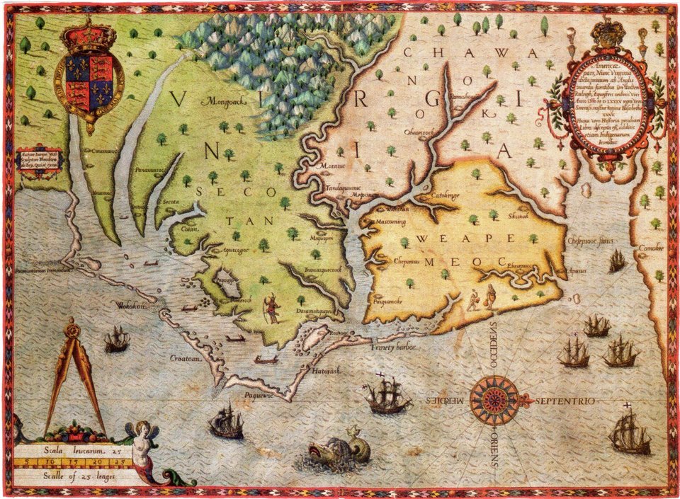
What is known about Roanoke comes almost entirely from a handful of accounts printed by Richard Hakluyt at the end of the sixteenth century, written by the participants themselves, and from the drawings and maps of John White, who was on three of the voyages. There is no record from the Indigenous side, except what the English wrote down about it. This dossier separates what those texts state from what was deduced later, and shows where today's archaeology disagrees with itself.
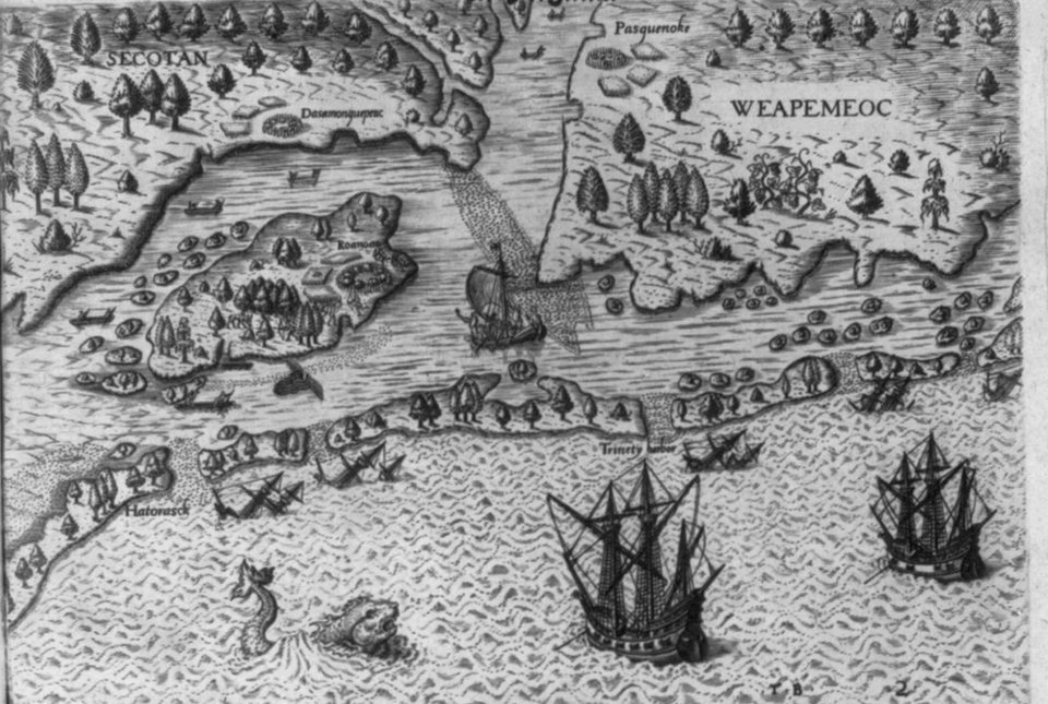
01Three voyages before the lost colony
In 1584, Queen Elizabeth I granted Walter Raleigh letters patent to establish colonies in lands not held by any Christian prince. That same year, Raleigh sent a reconnaissance expedition, commanded by Philip Amadas and Arthur Barlowe, with the Portuguese pilot Simon Fernandes. It reached the region in July, was well received by the Algonquians of Roanoke and returned in the fall bringing two men from the land: Manteo, from Croatoan Island, and Wanchese, from Roanoke. The region was named Virginia, in honor of the queen.
In 1585 came the second voyage, a military one: under the command of Richard Grenville, about a hundred and eight men, governed by Ralph Lane, stayed on the island. Among them were the mathematician Thomas Hariot and John White himself, charged with drawing the people, the animals and the plants. Relations with the neighbors soured quickly — the English depended on the Algonquians' corn in a bad year, and answered with threats. On June 1, 1586, Lane attacked the village of Dasamonquepeuc and killed the chief Wingina, who by then went by the name Pemisapan. Weeks later, Francis Drake passed along the coast, and the demoralized colonists went back with him to England.
Grenville's supply ship arrived shortly afterward and found the fort empty. So as not to lose possession, Grenville left fifteen men on the island. They too disappeared — and this is where the pattern begins.
02The 1587 colony and Virginia Dare
The third voyage was different from the earlier ones. It carried not soldiers but families: men, women and children who would receive land, under a company called the "City of Raleigh." John White went as governor. The destination was not Roanoke but Chesapeake Bay, farther north, where there was a deep harbor. The idea was only to stop at Roanoke to pick up Grenville's fifteen men.
On July 22, 1587, the colonists landed on the island and found no one, only the bones of one man. Simon Fernandes, the pilot, refused to go on to Chesapeake and left the colonists there. The accounts present the decision as his; why he made it is not known.
How many stayed is the first divergence. The list of names Hakluyt printed has 17 women and 11 children; the men vary between 85 and 91, depending on whether one subtracts those who went back with White and those who died, and there are two babies born on the island. The total that circulates, 117, is one possible reading of that list, not a number fixed in the source. The counts run from about 110 to 119.
The following month was tense. A colonist, George Howe, was killed while fishing alone, a few days after the arrival. In August, the English launched a dawn attack on what they thought was the people responsible and struck, by mistake, people from Croatoan, the only allies they had. Manteo, who was with them, was baptized and given an English title. On August 18 Virginia Dare was born, daughter of Eleanor, White's daughter, and of Ananias Dare — the first child of English parents born in the Americas, according to the English records. She was baptized the following Sunday.
The colonists then asked White to go back to England to hurry the supplies along. He hesitated — he would be leaving his daughter and granddaughter — and ended up going, on August 27. Before leaving, he agreed on a code: if the colonists left the island, they would carve the name of the place they were going; if they left under threat, they would add a cross. White also recorded that they were already thinking of moving "fifty miles into the maine." Both sentences would weigh in 1590 and, again, in 2012.
03Three years late: the war in the way
White reached England at the end of 1587, at the worst possible moment. Spain was preparing the Invincible Armada, and the Crown forbade the departure of ships capable of fighting. In April 1588, White managed to leave with two small vessels, the Brave and the Roe. One of them was attacked and plundered at sea, and both turned back without reaching America. After the battle against the Armada, it still took two years for a voyage to be organized.
On the other side, Spain was looking for the colony in order to destroy it. In 1588, a small expedition out of Spanish Florida, under Captain Vicente González, sailed along the coast and reported signs of English presence — an anchorage, barrels buried in the sand — but no Englishmen; exactly where it went is still debated. There is no record of a Spanish attack on Roanoke.
In 1998, a team led by the dendrochronologist David Stahle published in Science a reconstruction of the region's rainfall based on the rings of ancient cypress trees. The result: 1587 was the worst growing season in eight centuries, and the drought stretched until 1589. It is a physical fact, not an account. It explains the lack of food and the pressure on the neighbors who had corn to share. It does not explain, on its own, where the colonists went.
04CROATOAN: what White found in 1590
White came back with a fleet of privateers, more interested in hunting Spanish ships in the Caribbean than in rescuing colonists. In mid-August 1590, the ships reached the Outer Banks. They saw smoke on the island and went there. Crossing the bars, one of the boats capsized and seven men drowned, among them Captain Edward Spicer.
On August 18 — Virginia Dare's third birthday — White entered the settlement. In a short, dry account, he describes what he saw: the houses had been taken down, and in their place stood a high palisade of logs, which had not existed when he left. On one of the posts at the entrance, in large letters, the word CROATOAN was carved. On a tree, near the shore, the letters CRO. There was no cross on either. Chests the colonists had buried were found opened and rifled, among them some of White's own, with drawings and maps ruined by the rain.
White read the message as good news: Croatoan Island was the land of Manteo, an ally of the English, about eighty kilometers to the south. The agreement had been kept, and without the danger sign. He intended to go there the next day. A storm parted cables, the ships lost anchors, and the captain decided to put back out to sea. The fleet went on to the Azores and then to England. White never returned to America.
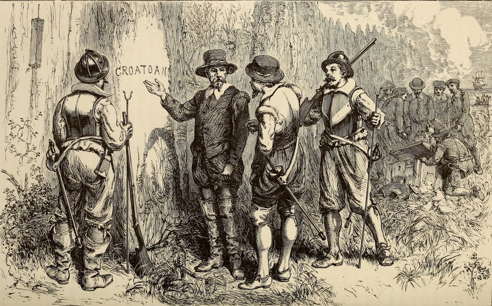
05What Jamestown heard
England only truly returned to the region in 1607, with Jamestown, on Chesapeake Bay. The colonists there had orders to search for the Roanoke survivors, and they gathered rumors. John Smith heard from Indigenous chiefs about men dressed like Europeans in places called Ocanahonan and Pakerakanick, to the south. A map from that period, known as the Zúñiga map because it was copied for Spain, notes at a point in the interior that four clothed men "that came from roonock" were there. Expeditions were sent and came back without finding anyone.
The gravest accusation came later. In 1609, the Virginia Council, in London, began asserting that the Roanoke colonists had been killed on the orders of Wahunsenacawh, the chief the English called Powhatan. William Strachey, around 1612, repeated the story in detail: the massacre would have happened shortly before the arrival at Jamestown, and seven people would have escaped. In 1625, Samuel Purchas wrote that Powhatan himself had confessed the crime to Smith.
The problem is that none of this appears in the writings of Smith, who is the one who would have heard the confession. The massacre version surfaces precisely when the Virginia Company had an interest in justifying war against the Powhatan, and no excavation has ever found what it assumes. It is not a hypothesis to be discarded for good — the Jamestown rumors existed — but it is the one with the weakest and most self-interested documentary basis.
06The Eleanor Dare stone
In 1937, a tourist named Louis Hammond presented a stone he said he had found near the Chowan River, in North Carolina. On it was a carved message, signed by Eleanor Dare and addressed to her father: the colonists had gone inland, Virginia had died, and most of the group had been killed. The stone was taken to Brenau College, in Georgia, whose professor Haywood Pearce began paying for new finds. They came: a Georgia stonecutter, Bill Eberhardt, and others delivered dozens of stones, telling a saga that crossed the Carolinas into Georgia.
In 1941, a report by Boyden Sparkes in the Saturday Evening Post showed that the finders knew one another and that the stones of the second batch were forgeries. The first one, Hammond's, remained in limbo: an analysis carried out in 2016 by Brenau, with samples tested at the University of North Carolina at Asheville, reached no conclusion. About forty-eight stones remain in the collection of what is now Brenau University. Eberhardt's are forgeries; Hammond's has no demonstrated authenticity, and most researchers treat it with suspicion.
07Two excavations, two answers
Roanoke archaeology has a peculiarity: the two most active projects say they have found the colonists, and in different places. Both start from one of White's sentences.
Hatteras: following the word
The first line follows CROATOAN to the letter. Since 2009, the Croatoan Archaeological Society, founded by the historian Scott Dawson, a native of Hatteras, has been excavating plots in Buxton and Frisco with the British archaeologist Mark Horton, affiliated first with the University of Bristol and later with the Royal Agricultural University. They report thousands of pieces: sword fragments, firearm parts, a slate writing tablet, glass, beads and copper Nuremberg tokens, mixed in the same layer with Indigenous pottery and arrowheads. In 2025 they announced forge scale — small flakes of iron that fly off when the smith hammers the metal — and iron bars, which they took as a sign that Englishmen lived and worked there, and did not merely trade objects.
The risk of this line is the opposite of what it seems. European pieces in an Indigenous village may have arrived through trade, through passing ships, or after 1607, by way of Jamestown. A ring engraved with a lion, found on Hatteras in 1998 and presented for years as a colonist's, turned out to be brass and, according to critics, lay in a layer that may date from the seventeenth century. Charles Ewen, an archaeologist at East Carolina University, sums up the objection: an unequivocal context, such as a complete forge, is missing, and so is a published, peer-reviewed report.
The interior: following the map
The second line follows the "fifty miles." In 2012, the First Colony Foundation and the British Museum announced that one of two paper patches glued onto John White's original map, known as La Virginea Pars, hid, when seen against the light, the symbol of a fort at the head of Albemarle Sound, near the confluence of the Chowan and Roanoke rivers — about fifty miles west of the island. No one knows why the symbol was covered: a correction to the drawing, secrecy in the face of Spain, or something else.
The indicated spot was named Site X, in Bertie County. The team of the archaeologist Nicholas Luccketti excavates there and at a second spot, Site Y, a few kilometers away. They report English pottery of a type used at the end of the sixteenth century, a cloth seal from Augsburg and the absence of the London clay pipes that seventeenth-century English traders carried everywhere — an argument that the material predates Jamestown. The results came out in a book at the end of 2023, edited by Eric Klingelhofer and published with the University of North Carolina Press. The criticism is the same as for the other line, in reverse: pottery of this type was made for a long time, and the dating depends on style, not on direct measurement.
08What changed in 2026
Both projects went public in 2026 with stronger claims than ever, and neither with a peer-reviewed paper as of the date of this dossier.
On March 26, 2026, at the Coastal Studies Institute, in Wanchese, on Roanoke Island itself, the bioarchaeologist Beth Scaffidi, of the University of California, Merced, presented with Mark Horton and Scott Dawson a talk titled, with a question mark, "The Smoking Gun?". The material is the food-refuse middens of the Hatteras villages: bones of deer and other animals, radiocarbon-dated and analyzed by isotopes. The most cited find is the jaw of a deer with a musket ball still lodged in it, with a date presented as consistent with the final decades of the sixteenth century. Horton described the picture as "peaceful assimilation." It is the most direct argument the Hatteras line has ever presented — and it is still a presentation, not a publication.
In June 2026, the First Colony Foundation published a text titled "The Lost Colony is Found!", maintaining that Sites X and Y, about eighty kilometers west of Roanoke, sheltered colonists: a small group, mixed with Indigenous material, at Site X, and a larger one, without Indigenous material, at Site Y, which the foundation describes as the largest collection of Elizabethan artifacts ever found in North America.
In other words: in 2026, the colony was announced as found twice, in two different places, by teams that do not endorse each other's work. That does not mean both are wrong. It means the case is not yet closed, however much the headlines say otherwise.
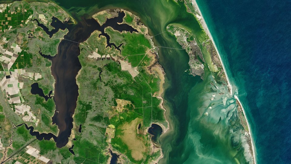
09The readings, from the most sober to the most improbable
The colonists went to live with the people of Croatoan
It is the reading White himself made, and the one the period sources support most directly: the name on the post, without a cross, pointed to the land of an ally. At the beginning of the eighteenth century, the explorer John Lawson recorded that the Hatteras people said they had white ancestors and that some had light-colored eyes. The excavations at Buxton and Frisco yield European material from the period mixed into Indigenous life. What keeps the weight from being high is the lack of peer-reviewed publication and the difficulty of telling coexistence from trade.
They went inland, where the map hid a fort
It fits the fifty-mile plan White recorded, the symbol covered on the map and the Jamestown rumors about Englishmen in the interior. The pottery from Sites X and Y is consistent with the end of the sixteenth century. But it is also consistent with decades later, and the symbol on the map may be just a correction to the drawing.
They split up, and each group had its own fate
It reconciles White's two clues and the two excavations. It is the hypothesis most often cited by those not tied to either project. Being the most accommodating, it is also the hardest to test: any find in either place confirms it.
They were killed by the Powhatan
It depends on secondhand accounts written between 1609 and 1625, when accusing Powhatan served the Virginia Company's war. The confession Purchas attributes to Smith is not in Smith's texts. There may be a grain of truth about a remnant group in the interior; as an explanation for the entire colony, it does not hold up.
They died of hunger, disease, or at sea trying to get back
The drought of 1587 to 1589 is real and measured, and an attempt to return to England in a small boat is possible. But a colony wiped out on the spot would leave dead bodies, and a departure by sea would explain neither the message on the post nor the chests deliberately buried.
A disappearance with no natural explanation
The "vanished without a trace" version, with a curse or worse, owes more to the theater than to the sources. Since 1937 the island has staged every summer the play The Lost Colony, by Paul Green, which helped fix the idea of an unsolvable mystery. The sources say otherwise: the colonists took down the houses, raised a palisade, buried the chests and left word in writing of where they were going. People who vanish without explanation do not leave a note.
10Chronology
- March 1584Elizabeth I grants Walter Raleigh letters patent to colonize.
- July 1584Amadas and Barlowe reach the region and return in the fall with Manteo, from Croatoan, and Wanchese, from Roanoke.
- 1585About 108 men, under Ralph Lane, stay on Roanoke. Thomas Hariot and John White are among them.
- June 1, 1586Lane kills the chief Wingina (Pemisapan). Weeks later, the colonists leave with Francis Drake.
- summer of 1586Grenville finds the fort empty and leaves fifteen men. They disappear.
- July 22, 1587John White's colony of families lands on Roanoke; the pilot refuses to go on to Chesapeake.
- August 18, 1587Virginia Dare, White's granddaughter, is born.
- August 27, 1587White leaves for England in search of supplies.
- 1587 – 1589The worst drought in the region in eight centuries, according to tree rings.
- April 1588White's attempt with the Brave and the Roe fails after an attack at sea. The Spanish Armada keeps English ships in port.
- August 18, 1590White finds the settlement empty, CROATOAN on a post and CRO on a tree, with no cross. A storm prevents the trip to Croatoan.
- 1607 – 1612Jamestown gathers rumors of Englishmen in the interior; Strachey records the version of a massacre by Powhatan.
- 1625Samuel Purchas attributes to Powhatan a confession to Smith that does not appear in Smith's writings.
- 1701 – 1709John Lawson records, among the Hatteras people, the tradition of white ancestors.
- 1937The play The Lost Colony premieres on the island. Louis Hammond presents the first Dare stone.
- 1941The Saturday Evening Post exposes the Dare stones as forgeries. Fort Raleigh National Historic Site is created.
- 1998Stahle and colleagues publish the 1587–1589 drought in Science. A ring with a lion is found on Hatteras.
- 2009Scott Dawson and Mark Horton begin their excavations on Hatteras.
- May 2012The British Museum and the First Colony Foundation announce the fort symbol hidden under patches on White's map: Site X is born.
- November 2023The First Colony Foundation publishes the results from Sites X and Y in a book.
- May 2025The Hatteras team announces forge scale and iron bars.
- March 26, 2026Scaffidi, Horton and Dawson present dates and isotopes from Hatteras animal bones, including the deer jaw with a musket ball.
- June 2026The First Colony Foundation declares the colony "found" at Sites X and Y.
11What remains open
Where the 1587 settlement was. It has still not been located with certainty on Roanoke Island. Part of the island's north shore has been eaten away by erosion since the sixteenth century, and the site may be underwater.
Who reached Croatoan, and how many. The Hatteras pieces show English objects of the period in an Indigenous village. Showing that their owners were the 1587 colonists, and not trade, depends on a complete, peer-reviewed report that has not yet come out.
What the patch on the map was hiding. A planned fort, a built fort or a corrected mistake: the answer changes the weight of Site X as a whole.
Whether there are descendants. DNA projects have tried, since 2005, to link today's families to the names on the 1587 list and have reached no confirmation. Traditions of ancestry in Indigenous and mixed-heritage communities in the region exist and deserve respect, but they are not genealogical proof — and the DNA of four centuries of mixing is unlikely to give a clean answer.
12Frequently asked questions
What happened to the Roanoke colony?
It is not known with proof. In 1590, John White found the settlement empty and the word CROATOAN on a post, without the agreed danger sign. The best-supported readings are that the colonists went to live with the people of Croatoan, that they went inland, or that they split up. See the readings.
What does CROATOAN mean?
It is not a coded message: it is the name of an island and of a people, the land of Manteo, an ally of the English, about eighty kilometers south of Roanoke — the southern stretch of present-day Hatteras. Under the agreed code, the colonists would carve the name of the place they were going, and a cross if they left under threat. There was no cross. See what White found.
How many colonists disappeared at Roanoke?
The counts run from about 110 to 119. The list of names printed by Hakluyt has 17 women and 11 children, and the total of 117 that circulates is one possible reading of it, not a number fixed in the source. See the 1587 colony.
Has the lost colony of Roanoke been found?
In 2026, the colony was announced as found twice, in different places: on Hatteras, the former Croatoan, and at Sites X and Y, in the interior. Neither project had a peer-reviewed paper as of the date of this dossier. See what changed in 2026.
13Sources consulted
This dossier is original writing. The sources below were consulted to verify dates, figures and attributions; none was reproduced.
- Hakluyt, R. — The Principal Navigations, Voyages, Traffiques and Discoveries of the English Nation, 1589 and 1598–1600, with the accounts by Barlowe, Lane and John White of the voyages of 1584, 1585–1586, 1587 and 1590.
- Hariot, T. — A Briefe and True Report of the New Found Land of Virginia, illustrated edition by Theodor de Bry, 1590.
- Quinn, D. B. (ed.) — The Roanoke Voyages, 1584–1590. Hakluyt Society, 1955.
- Strachey, W. — The Historie of Travell into Virginia Britania, c. 1612. Purchas, S. — Purchas his Pilgrimes, 1625.
- Stahle, D. W. et al. — The Lost Colony and Jamestown Droughts. Science, 1998.
- Consolidated encyclopedia entries on the Roanoke colony, the list of colonists, the Dare stones and Fort Raleigh National Historic Site; National Park Service, Fort Raleigh National Historic Site.
- Lawler, A. — The Secret Token: Myth, Obsession, and the Search for the Lost Colony of Roanoke. Doubleday, 2018.
- Dawson, S. — The Lost Colony and Hatteras Island. The History Press, 2020.
- Klingelhofer, E. (ed.) — Excavating the Lost Colony Mystery. First Colony Foundation and University of North Carolina Press, 2023.
- National Geographic — report on Sites X and Y and the criticisms by Charles Ewen, November 5, 2020; Live Science — on the assimilation claims on Hatteras and the objections to them.
- Island Free Press — on the forge scale on Hatteras, May 15, 2025.
- The Outer Banks Voice — on the presentation by Scaffidi, Horton and Dawson at the Coastal Studies Institute, March 27, 2026; Coastal Review, March 2026.
- First Colony Foundation — "The Lost Colony is Found! How We Did It.", June 4, 2026.